
GARMIN GPSMAP 1223
Product details
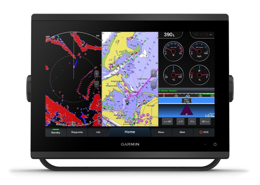
The new GPSMAP series from Garmin has a significantly higher resolution and even faster processing power. The 12″ touchscreen display features an optimised map display, excellent user interface and can be easily integrated into the Garmin marine system. In addition, its bright screen is even easier to read in sunlight.
Garmin Sailassist
See laylines, start line guidance, an enhanced wind rose, heading and course-over-ground lines,true and apparent wind data, and controls for tide, current and time, wind angle, drift, current, wind speed and more.
Optional bluechart sea charts
The Bluechart g3 and Bluechart g3 Vision maps combine the best data from Garmin, Navionics, Auto Guidance technology and other premium navigation features.
Garmin Marine Network
Easily share information with other Garmin devices on your boat, such as maps, user data, radar data and IP camera data.
NMEA2000 and NMEA0183 compatibility
Connect your chartplotter directly to autopilots, digital switching, weather data, the FUSION Link audio system, media, VHF, AIS and more.
ActiveCaptain app
Connect your device to Wi-Fi and link it to the free mobile ActiveCaptain app. This gives you access to the OneChart feature, Smart Notifications, software updates, Garmin Helm, Garmin Quickdraw community, and more.
Integrated ANT technology
Easily connect your devices such as quatix marine clocks, gWind Wireless 2 transducers, GNX Wind marine instruments and radio remote controls to the GPSMAP Plus.
JI939 connectivity
Easily integrate data from different engines (including Yamaha engines).
ONEHELM function
This function displays all third-party options on one page, e.g. EmpireBus Digital Switching.
PANOPTIX support
Connect your chartplotter to the easy-to-read PANOPTIX or PANOPTIX LIVESCOPE sonar (transducers sold separately) and get a real-time, all-round view under and alongside your boat.
Technical Data
General
| Dimensions | 308 x 228 x 82 mm |
| Display size, W x H | 12.1″ diagonal (262 x 163 mm) |
| Display resolution, W x H | 1280 x 800 pixels |
| Display type | WSVGA-display |
| Weight: | 3.0 kg |
| Water rating | IPX7 |
| Polarized support | Yes |
| JI939 connectivity | Yes |
| Power consumption | Max. power consumption at 10 V DC: 26.5 W Typical current consumption at 12 V DC: 1.7 A Max. current consumption at 12 V DC: 2.2 A A |
| Antenna | Internal or external via NMEA2000 |
| Mounting options | Installation with bracket or flush |
| Receiver | Highly sensitive with 10 Hz |
| Garmin Marine Network ports | 2 |
Maps and memory
| Preinstalled chart | Worldwide base map |
| Accepted data cards | 2 microSD memory cards; maximum 32 GB |
| waypoints | 5000 waypoints |
| routes | 100 routes |
| Track log | 50,000 points, 50 saved tracks |
Outdoor recreational features
| Tide tables with optional Bluechart map | Yes |
Further functions
| Compatible with GARMIN radars | Yes |
| Compatible with GARMIN sonars | Optional (with external black box, sold separately) |
| Compatible with GARMIN Smartmode (customisable screen presets) | Yes |
| AIS support | Yes |
| DSC support | Yes |
| Fusion Link compatibility | Yes |
| ActiveCaptain compatibility | Yes |
| Supports GSD™ black box sonar | Yes |
| Supports GCV™ black box sonar | Yes |
| Compatible with GRID (Garmin remote input device) | Yes |
| Compatible with radio remote control | Yes |
| Sailing features | Yes |
Sonar functions
| Chirp sonar technology | Optional (with external black box) |
| Clearvü | Optional (with external black box, sold separately) |
| Sidevü | Optional (with external black box, sold separately) |
Connections
| NMEA2000® compatible | Yes |
| NMEA0183 inputs | 1x |
| NMEA0183 outputs | 1x |
| Video input ports | 1x BNC |
| Video output ports | 1x HDMI |
| Wireless connectivity | Yes |
Delivery contents
1x microSD™ card preinstalled
1x power cable
1x NMEA 2000® T
1x NMEA 2000 power cable (2 metres)
1x mounting bracket set with fastening knobs
1x flush mounting kit with gasket
1x protective cover
1x click rims for mounting
1x documentation
Reviews
There are no reviews yet.